Projects
Muckanippie
Project
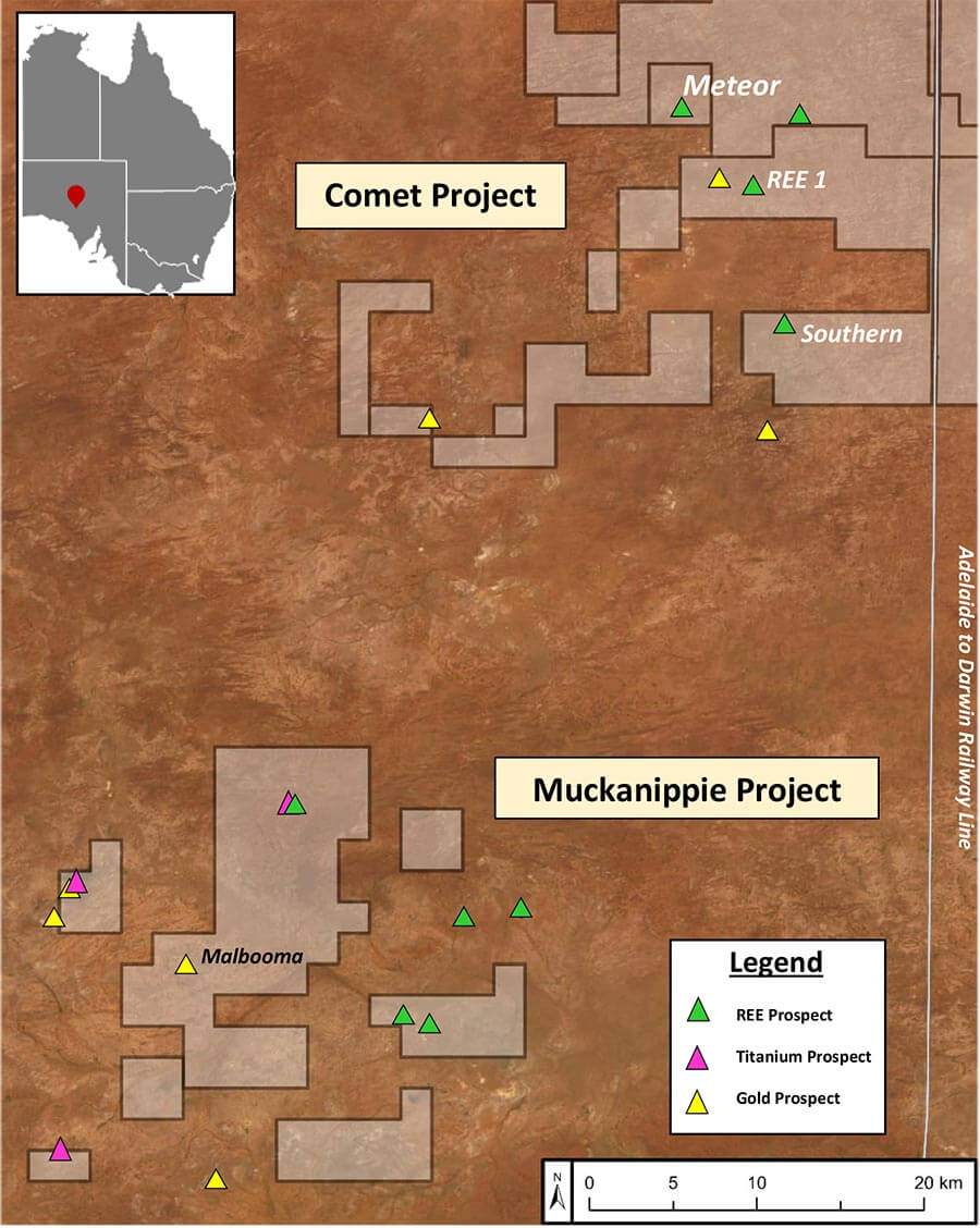
The Muckanippie Project Comprises two tenements (EL6855 & EL6815) totalling 258 km2 area over the central and outer portions of a regionally extensive layered intrusive sequence known as the Muckanippie Anorthosite Complex (Figures 2 & 3). The layered complex shows evidence of rare earth (REE) and ferro-titanium enrichment. The licences build on encouraging Rare Earth results at PTR’s Comet Project Area 40 kilometres to the northeast (Figure 1, refer to PTR ASX releases 20/04/2022, 08/08/2022 & 29/08/2022).
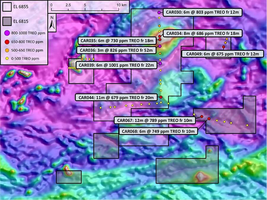
Rare Earths at Muckanippie (See Figure 2)
Re-assaying of open file historic government and company drilling has outlined several areas with anomalous REE’s in the weathered clay rich profile (Figure 2). In all, 44 holes were re-assayed with one composite sample of the upper saprolite clay horizon and a second composite sample taken at the base of each hole over the saprock zone (refer to Table 2 of significant intercepts). In particular, the broad spaced sampling highlights the central magnetic zone of the Muckanippie Anorthosite Complex (Figure 2) as being highly elevated in REEs ranging between 700 to 1000 ppm Total Rare Earth Oxide (TREO), providing an immediate focus for initial ground exploration works.
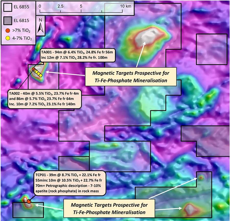
Magnetite Iron and Titanium Dioxide at Muckanippie (See Figure 3)
The Muckanippie Anorthosite Complex includes a number of mafic intrusive bodies and mafic horizons (Figure 3). Limited historical drilling by other explorers has shown broad intervals of highly anomalous titanium and iron, and petrological studies describe abundant apatite, a source of rock phosphate (chemical formula Ca5(PO4)3(F,Cl,OH) associated with these mafic complexes. Historic drill hole TCP01 (Figure 3) recorded 39m @ 8.7% TiO2, 22.1% Fe from 55m inc. 10m @ 10.5% TiO2 + 22.7% Fe from 70m. Although no historical phosphate assays were undertaken, later petrological analysis of the core describes apatite concentrations averaging 7 to 10% of the total rock mass.
Globally, anorthosite complexes relate to specific geological environments and are reasonably uncommon. However, they have often been found to be a major source of titanium, iron, vanadium and phosphate ores. Table 1 provides a summary of some notable deposits hosted within anorthosites from around the world. These ores are associated with the mafic portions of the intrusive complex and are generally easily defined using magnetic data as the iron mineralisation associated with the ores is mostly in the form of magnetite.
At Muckanippie, Figure 3 highlights several prominent magnetic areas for follow up. These bodies have only been lightly explored for this style of mineralisation with substantial portions of the prospective magnetic intrusions remaining open for future testing.
Table 1 – Examples of Anorthosite Hosted Mineral Deposits from Around the World
| Deposit | Country | Commodities | Characteristics of Deposits* |
| Lac Tio | Canada | Ti – Fe | 138 Mt @ 60% wt. hemo-ilmenite; TiO2 content ranges between 32-38 wt.% |
| Tellnes | Norway | Ti | 380 Mt @ 18 % TiO2 |
| Damiao | China | Fe-Ti-V- P2O5 | resource size unknown – recorded average production of 2Mt of ore per year @ 36 wt.% Fe2O3, 7.0 wt.% TiO2, 0.3 wt.% V2O5, and 2.0wt.% P2O5 |
| Lac á Paul | Canada | Ti-P2O5 | 472.09 Mt at 6.88% P2O5 |
*Characteristics of Deposits sources: Lac Tio & Tellnes – Charlier, B, Namur, O, Bolle, O, Latypov, R & Duchesne, J-C 2015, ‘Fe–Ti–V–P ore deposits associated with Proterozoic massif-type anorthosites and related rocks’, Earth-Science Reviews, vol. 141, pp. 56–81. Damiao – Chen, WT, Zhou, M-F & Zhao, T-P 2013, ‘Differentiation of nelsonitic magmas in the formation of the ~1.74 Ga Damiao Fe–Ti–P ore deposit, North China’, Contributions to Mineralogy and Petrology, vol. 165, no. 6, pp. 1341–1362. Lac á Paul – proven and probable reserve; 2013 – Arianne Phosphate Inc., NI 43-101 Technical Report – Feasibility Study to Produce 3Mtpy of High Purity Apatite Concentrate at the Lac a Paul Project, Québec, Canada., https://www.arianne-inc.com/wp-content/uploads/2022/06/43-101.pdf